Custom SQL queries and saving them in your project
Write any SELECT against Databricks, preview the results, and add them to the map. Tick Save in project and the query is stored in your .qgz: it re-runs against Databricks every time the project opens, like a PostGIS SQL layer.
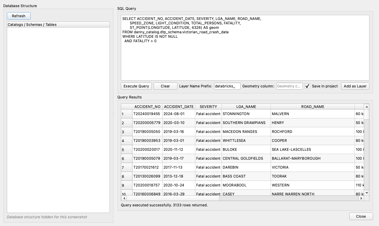
Open Custom Query
- Main dialog: load a saved connection, then click Custom Query... (bottom left).
- Browser panel: right-click a connection → Execute Custom Query...; right-click its ⚡ Custom Query item → Execute Query...; or right-click a table → View Data... (pre-fills
SELECT * … LIMIT 100)
The left side, Database Structure, lists the catalogs, schemas and tables you can access (click Refresh to reload).
Run a query
- Type or paste your SQL into SQL Query.
- Click Execute Query. Query Results shows the rows, with a summary like "Query executed successfully. 3133 rows returned."
Getting geometry into a query
The layer needs a GEOMETRY or GEOGRAPHY column:
- Tables with geometry: select the column, e.g. SELECT id, name, geom FROM ….
- Latitude/longitude numbers: build a point with ST_POINT(longitude, latitude, 4326) AS geom.
- Text (WKT): ST_GEOMFROMWKT(wkt_column); give it a coordinate system with ST_SETSRID(…, 4326).
- H3 cells: ST_GEOMFROMWKT(h3_boundaryaswkt(h3_cell)).
Leave Geometry column empty to detect it automatically, or type the column name if your query returns more than one.
Add the results as a layer
Temporary layer (default)
- Leave Save in project unticked.
- Optionally change Layer Name Prefix.
- Click Add as Layer.
The layer holds a copy of the results. It's fast for small results, but it's not kept when the project is closed.
Save a query in your project
- Run the query with Execute Query first. Save in project saves the query you last executed.
- Tick Save in project.
- Click Add as Layer. You'll see "…saved with the project and re-queries Databricks each time the project is opened."
- Save your project (Project → Save,
.qgz).
Next time anyone opens the project, the layer re-runs your query and draws. Behind the scenes: - Only the visible area is fetched. Zoomed in, only nearby features load, so even large queries stay responsive. - Select, identify and the attribute table work, with stable feature ids. - Refresh (right-click the layer → Refresh, or the Refresh button) re-reads the query, picking up new data. - The project stores the SQL and the connection's name, never a token. See Security and privacy.
Rules for saved queries
- One
SELECT(orWITH … SELECT) statement. A trailing;and--comments are fine; other statements are refused. - Personal access token connections must be saved first. The layer refers to the connection by name, so the token stays in your QGIS settings and out of the project file. If it isn't saved, you'll see "Save this connection first…". OAuth connections work either way.
- Queries without geometry (e.g. a summary table) become attribute-only layers: no map symbol, but the attribute table works.
Temporary vs. saved: which to use?
| Temporary layer | Save in project | |
|---|---|---|
| Kept when you reopen the project | No | Yes |
| Data | Copy at the time you added it | Re-queried from Databricks on open and on refresh |
| Large results | Loaded all at once | Only the visible area is fetched |
| Editable in QGIS | Yes (local copy only) | Read-only |
| Needs the plugin to open the project | No | Yes |
Share a project with saved queries
- Save the project (
.qgz) and send it. - Your colleague needs the plugin installed and access to the same tables in Databricks.
- OAuth layers: they open the project and sign in with their own account. If they don't have a connection with the same name, the layer uses the workspace host and path from the project with their sign-in. Results respect their permissions.
- Personal-access-token layers: your colleague creates a connection with the same name and their own token. Until then, QGIS shows the layer in Handle Unavailable Layers. That's expected, not an error.
Example queries
Replace the table names with your own.
Points from latitude/longitude
SELECT ACCIDENT_NO, ACCIDENT_DATE, SEVERITY, LGA_NAME,
       ST_POINT(LONGITUDE, LATITUDE, 4326) AS geom
FROM my_catalog.transport.road_crashes
WHERE LATITUDE IS NOT NULL AND FATALITY > 0
Hexagon hotspots (H3)
WITH cells AS (
  SELECT h3_longlatash3(LONGITUDE, LATITUDE, 7) AS h3_cell, COUNT(*) AS crashes
  FROM my_catalog.transport.road_crashes
  WHERE LATITUDE IS NOT NULL
  GROUP BY h3_longlatash3(LONGITUDE, LATITUDE, 7)
)
SELECT h3_cell, crashes,
       ST_SETSRID(ST_GEOMFROMWKT(h3_boundaryaswkt(h3_cell)), 4326) AS geom
FROM cells
WHERE crashes >= 20
crashes for a heat map: see Basemaps and styling.
Summary table (no geometry)
SELECT LGA_NAME, COUNT(*) AS crashes
FROM my_catalog.transport.road_crashes
GROUP BY LGA_NAME
ORDER BY crashes DESC
Tip: like any SQL editor, Execute Query runs your statement as typed, with your Databricks permissions. Save in project keeps layers to a single
SELECT, so saved projects only ever read data.